THE establishment of the new MDAT-GoG reporting “network” in the Gulf of Guinea and the associated changes to UKHO chart Q6114, have raised old questions about the definitions and purpose of risk and reporting areas associated with maritime piracy.
In general terms, these areas are meant to help establish situational awareness of maritime traffic, threats and response options to help vulnerable shipping vessels. A number of different areas or zones have been established in regions affected by piracy around the world, including Voluntary Reporting Areas (VRAs), High Risk Areas (HRAs), and War Risk Listed Areas (WRAs), along with other more specialized zones. These terms are frequently used interchangeably, which distorts the purpose of the different areas and creates confusion. This paper is intended to provide clarity on the differences between these zones, and their implications for stakeholders.
Definitions:
Voluntary Reporting Areas: Established by regional reporting centers such as UKMTO, IFC, or the new MDAT-GOG. Vessels report information such as location, counter-piracy measures, speed, etc. on a voluntary basis at the request of the reporting center to help in the development of a comprehensive Maritime Situational Awareness (MSA) picture of traffic, threat, and response awareness within the area. This information facilitates threat assessments, resource allocation, and response planning by maritime law enforcement and navies.
High Risk Areas: Established by the shipping industry and other stakeholders, these areas are designated as an indication of increased risk to vessels and crew. The most well-known is the HRA which was established as a response to Somali piracy in the Indian Ocean, and reduced in size on 1 December, 2015. However, numerous other HRAs have been established in other piracy affected regions by individual flag states, security companies, and shipping companies. These areas have implications for industry standards related to counter-piracy measures.
War Risk Listed Areas: Established by insurance companies and mutual clubs, either individually or through the Joint War Risk Committee (JWC), these areas provide a recommendation to insurers relating to increased additional premiums for hull-risk policies. The two most pertinent for piracy are the JWC Listed Areas in the Indian Ocean and the Gulf of Guinea. The Indian Ocean JWC Listed Area was reduced in size to cover an

area similar to, but not identical with, the BMP HRA.
Regional Piracy Related Areas:
Western Indian Ocean Region:
-
VRA: The UKMTO VRA was established in 2002 in response to a maritime terrorism threat, not piracy, though that has become an important part of its mission.
-
HRA: The HRA, originally established by BMP4, was reduced in size in December, 2015. and
-
Listed Area: Not pictured, revised in December, covers a roughly similar area to the HRA.
Gulf of Guinea: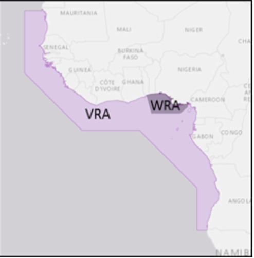
-
VRA: The pictured VRA was established by MTISC-GOG, and has been modified, and increased in size by MDAT-GOG to include Cape Verde and drawing a straight line down the coast.
-
HRA: No industry wide HRA exists for the Gulf of Guinea.
-
Listed Area: The JWC listed area encompasses the EEZs of Togo and Benin, and the EEZ and TTW of Nigeria North of 3 degrees.
Southeast Asia:
-
VRA: The IFC VRA tracks maritime crime and threats beyond piracy throughout the region, and the VRA exists to facilitate a white picture for the IFC.
-
HRA: The pictured HRA represents the specific area with the highest risk of piracy and armed robbery against ships in the region as defined by a single affected stakeholder.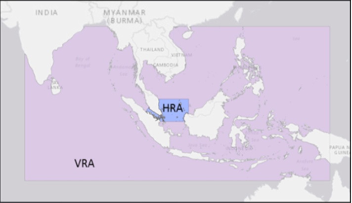
-
Listed Area: No JWC Listed Area is currently established for the Southeast Asia region.
While often overlapping, HRAs, VRAs, and WRAs are all established by different stakeholders and with different implications.
-
VRAs exist to facilitate a white picture for navies and maritime security agencies, and as a result are often much larger than either WRAs or HRAs. They also provide critical information for threat avoidance and response coordination.
-
WRAs exist to help insurers define specific regions where it is appropriate to charge an added premium due to a piracy or other war risks.
-
HRAs are established by industry as a warning to vessels and shipping companies of an increased piracy risk and to guide CSOs in implementing anti-piracy measures.
Flexible Zones?
This graphic (courtesy of CLS and DG Move) indicates that MSA requirements (and associated VRA, WRA or HRAs) could be tailored based on a common understanding of the threat in different geographic areas.
For example, in high threat areas, stakeholders may agree to a detailed voluntary reporting scheme and active coordination that would facilitate robust Traffic, Threat, and Response Awareness. However, in areas of diminished threat, these procedures may be unnecessary or undesired. Therefore, periodic, cross-sectoral assessments should be encouraged in order to ensure that the MSA schemes match the current state of threat.
Source: Oceans Beyond Piracy
 Subscribe to our newsletter. Receive a weekly round-up of all piracy-related & maritime situational awareness news.
OCEANUSLive.org
Information, Security, Safety; Shared
Submitted by Team@oceanuslive.org